

Electoral Commission concludes the revision of voting district boundaries for 2024 Elections, and launches campaign to re-register affected voters
The Electoral Commission has concluded the revision of voting district boundaries in an effort to increase voter access in the 2024 National and Provincial Elections. As a result, some new voting districts have been created, others have been disestablished, while some existing voting districts have changed shape.
The revision of voting district boundaries, a process known as re-delimitation, has given rise to 23 296 voting districts, compared to 23 148 for the 2021 Municipal Elections – an increase of 148 voting districts, or 0,6%.
“This increase in voting districts, however slight, implies increased access and convenience to voting for voters,” explains Chief Electoral Officer Sy Mamabolo.
Unlike wards, voting districts are not political boundaries, but are the creation of the Electoral Commission for the purposes of electoral efficiency and planning.
Mamabolo indicates that the Electoral Commission will embark on a campaign of targeted communication and re-registration (TCR) of voters affected by the voting district boundary changes on Monday, 2 October 2023. The campaign will continue until Friday, 27 October 2023, ahead of voter registration for the forthcoming elections.
By law, eligible voters must be registered in the voting district in which they ordinarily reside in order to participate in elections.
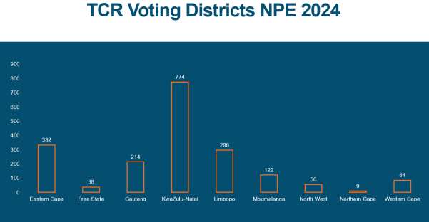
“Nationally there are 1 925 affected voting districts identified for this TCR campaign, the majority of which are in KwaZulu-Natal (774), the Eastern Cape (332) and Limpopo province (296),” says Mamabolo.
A breakdown per province of the number of voting districts affected by the redrawn voting district boundaries for the 2024 Elections is as follows:
The targeted communication and re-registration of voters affected by the voting district boundary changes will be done by a combination of methods taking into account the varied social milieus. The methods include trained fieldworkers walking from house to house in certain affected voting districts, and the use of direct messaging with affected voters via SMS and other digital channels to inform them of the need to re-register in their new voting districts.
“Our fieldworkers, identifiable by identification card and vest clearly marked with IEC branding, will be equipped with voter management devices (VMDs) to re-register voters on the spot,” adds Mamabolo.
Where voters are not home, a flyer will be dropped off communicating details of their new voting district and station, the national registration weekend dates, and also directing them to the Voter Portal where they can self-register online 24/7.
To find out if your voting district boundaries have changed, voters are encouraged to check their voter registration status on the Electoral Commission’s Voter Portal. Visit www.registertovote.elections.org.za or scan the QR code in the banner below, or SMS your ID number to 32810 to get a notification of the current voting district and station on record for you.
When you visit the Voter Portal or use the SMS line, your registration details will be displayed, including your voting district and station. If you have moved to a new home, you are most likely in a different voting district.
“We appeal to voters that if your voting district has indeed changed, it is important that you re-register in your new voting district to ensure that your name appears on the voters’ roll segment for your voting district on Election Day,” concludes Mamabolo.
The Electoral Commission will host the first registration weekend for the 2024 Elections on 18-19 November 2023, when all voting stations will be open from 8am to 5pm on both the Saturday and Sunday.
For media queries: Please contact Kate Bapela on 082 600 6386
For media interviews: Please email requests to: spokesperson@elections.org.za
Follow us on social media:
- Facebook: www.facebook.com/IECSouthAfrika
- Instagram: www.instagram.com/IECSouthAfrica
- X (formerly Twitter): @IECSouthAfrica
- YouTube: www.youtube.com/user/IECSouthAfrica
- Website: www.elections.org.za
- WhatsApp ‘Hi’ to 0600 88 0000
Frequently Asked Questions
The Electoral Commission’s Delimitation Division is responsible for delimiting (subdividing) the entire geographic area of South Africa into voting districts, with the assistance of a Geographical Information System, or GIS, electronic mapping system.
What is a voting district?
A voting district is the smallest geographical unit (area) for purposes of election planning and administration. Its usefulness lies in its ability to minimise electoral fraud (registered voters voting more than once in an election), and to make election administration more efficient.
Each voting district is serviced by a single voting station. Voters may only register and vote in the voting district in which they live. Once registered, a voter’s name will appear on the voters’ roll for the voting district at which they are registered. This minimises the possibility of a voter voting more than once in an election.
How are voting districts determined?
Voting districts are delimited to minimise voter inconvenience (voters having to travel inordinate distances to access a voting station and standing in long queues at voting stations), and to assist the Electoral Commission with logistical planning.
Voting districts are principally determined on the basis of geographical size and number of eligible voters. Urban voting districts contain typically 3 000 voters located
within a smaller radius of the voting station, while rural voting districts generally accommodate some 1 200 voters located within a relatively larger radius of the voting station.
What is delimitation and demarcation?
The concepts ‘delimitation’ and ‘demarcation’ are often used interchangeably. For the purposes of electoral management, the drawing of outer municipal boundaries is called re-demarcation, and drawing ward boundaries is termed delimitation. Both these processes are the legal responsibility of the Municipal Demarcation Board (MDB).
The drawing of voting districts is known as ‘delimitation’, and is within the remit of the Electoral Commission. Voting districts are created for electoral efficiency and planning purposes.
Why do voting districts change?
Many voting districts change shape due to various geographical, population and political changes that take place between elections.
When delimiting voting districts, the Electoral Commission accesses various data sources (topographic, cadastral, census information), including the Surveyor- General, the Department of Land Affairs and Statistics SA.
Before an election, the Electoral Commission’s municipal representatives inspect maps of voting districts in municipalities to align the geography of voting districts with local geographic, settlement, demographic and political changes that may have occurred since the previous election. Voting districts must also be aligned to new boundaries determined by the Municipal Demarcation Board.
Our municipal representatives also locate and confirm voting stations in each voting district. This is done in conjunction with municipal political representatives.
How will voters know if their voting district has changed?
Check your voter registration status online. All of your registration details will be displayed, including your voting district and station. If you have moved to a new home, you're most likely in a different voting district. To find out, go to our online voting station finder at https://maps.elections.org.za/vsfinder/ and search for your street name or suburb. The map will display your voting district boundaries and the location of your voting station. If your voting district has indeed changed, you need to re-register in your new district. Visit www.registertovote.elections.org.za or visit your voting station on the weekend of 18-19 November 2023, 8am-5pm both days.

